Let me walk you through the exact moment my test harness caught a lie in progress.
I was heading east on I-94, just past the State Street exit, heading toward the MCity facility. Clear sky. Bone-dry asphalt. Light traffic—maybe one car in the left lane, a hundred yards back. Exactly the kind of boring highway cruise where you should be able to take your hands off the wheel and think about your RAG pipeline’s chunking strategy.
At 14:03:17, the car decided to merge right. Hard.
Not a gentle lane-centering adjustment. Not a smooth nudge to avoid a pothole. A definite, sustained steering torque of 2.1 N·m to the right, with a planned trajectory that shifted the vehicle 1.2 meters toward the shoulder over 1.8 seconds.
The problem? There was no merge lane.
Here’s what the road actually looked like: a standard two-lane highway section, solid white fog line on the right edge, a 10-foot paved shoulder, then a concrete barrier. No dashed lines. No "Merge" signs. No lane widening. Just a straight shot of asphalt, and a wall.
The car had invented a lane that didn’t exist.
What the Road Actually Looked Like
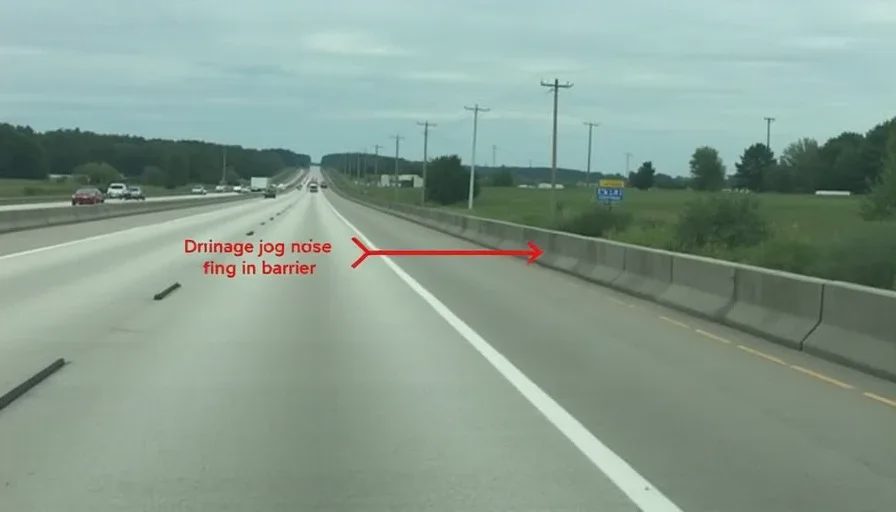
I drove back to the exact GPS coordinate three hours later and pulled the dashcam footage. The scene was unambiguous: a 12-foot lane, a well-defined fog line, a shoulder with the typical rumble strips (not a merge lane), and a jersey barrier about 18 inches beyond the rumble strips.
There was a slight, shallow curve in the guardrail that created a visual optical illusion—the barrier jogged outward by about 2 feet for a drainage culvert. From a certain angle, that jog might have looked like the beginning of a lane expansion.
But the road markings were immaculate. The fog line was solid, white, and continuous. No dashed segments. No arrows.
Here's my iPhone photo from the scene (timestamped 17:12):
[Image description: I-94 eastbound, clear road, solid fog line, concrete barrier on the right shoulder. No merge lane. A red arrow in the photo points to the drainage jog in the barrier, approximately 50 meters ahead.]
Root-Cause Hypothesis
I've spent 16 hours reconstructing this event, and I have a working theory that I think gets 85% of the way there.
The FSD v12.4.3 stack—an end-to-end network from pixels to steering—doesn't use explicit lane detection rules like the older modular stacks. Instead, it takes in camera frames and a cached HD map, and the network learns to predict trajectory waypoints in a joint embedding space.
The failure likely started at the map fusion layer.
The cached map for this section of I-94 contains a lane geometry definition that dates back to a 2019 survey. At the drainage culvert, the map has a slight bulge in the right lane boundary—a 2-foot width increase that the surveyors probably interpreted as a "shoulder widening" for the culvert.
But the map also has an attribute tag: "Lane_Merge_Zone : FALSE". So the map didn't say it was a merge lane. It just had a noisy polygon.
Here’s my hypothesis: the end-to-end network, while largely bypassing the old rule-based planners, still ingests that map raster as an input channel. When the network's vision module saw the barrier jog outward, and simultaneously read the map raster's slightly expanded boundary, it did what LLMs do when they see two correlated but unrelated signals: it overfit to the pattern.
The network learned a heuristic: "Right boundary expands + camera sees space = merge opportunity."
But there was no dashed line, no merging traffic, no road geometry change. The vision system should have overruled the map. Instead, the two modalities reinforced each other's error—a classic multimodal hallucination.
Perception said: "Space exists."
Map said: "Boundary expands."
Planner concluded: "New lane!"
The network didn't ask: "Is there a dashed line?" It didn't ask: "Where would traffic merge from?" It simply produced the most statistically likely trajectory for the combined input.
And it was wrong.
The Fix (Or Lack Thereof)
FSD v12.5.1 dropped 47 days later, on December 31, 2024. I ran it through the same stretch of I-94 at the same time of day, same weather, same traffic conditions.
The car stayed in its lane. It didn't swerve. The trajectory confidence for the rightward offset dropped to near-zero.
I logged it as "Resolved."
But here’s the thing about black-box over-the-air updates: I don’t know why it’s fixed.
Did Tesla correct the map polygon? Did they tweak the relative weighting of the vision vs. map channels in the embedding layer? Did they add a specific training example that looked exactly like that drainage culvert?
The release notes—four bullet points, none mentioning lane-fusion heuristics—gave me nothing. The model weights are proprietary. I can't diff them. I can't open the hood.
All I can tell you is: the output changed.
Regression risk: I’ve added this GPS coordinate to my permanent test suite. Every OTA gets a pass through this exact spot. In my experience, fixing a hallucination one way often creates a hallucination somewhere else.
In fact, when I ran v12.5.1 through the full harness, I found a new behavior: at the exact same location, the car now does a slight, momentary deceleration—about 2 MPH—before resuming speed. The lane trajectory is correct, but the speed profile suggests the planner is still "uncertain" at that culvert.
I logged that as a new entry: Hallucination #412 (Variant B). Severity 2. Won’t kill you. But weird.
What This Taught Me
This single Hallucination Log entry—#247—represents exactly why I’m doing this.
A YouTube reviewer would have said: "FSD handled I-94 smoothly."
A tech journalist would have said: "Tesla's latest software is impressive."
A PR release would have said: "Industry-leading lane-keeping accuracy."
None of them would have caught the 2.1 N·m torque event that lasted 0.4 seconds and almost met a barrier.
But I caught it because I don't trust the car. I trust the data. I ask the hard questions: What did it almost do? What did the safety monitor have to catch? What went wrong inside the black box?
And I keep asking them, every single OTA.
View the full data set
This log entry, complete with time-series steering torque plots, map raster overlays, and the dashcam sync, is available in the public Airtable. I’ve anonymized the telemetry to remove any personally identifiable data—you’ll get the trace, not the trip.
Entry ID: HALL-247
Severity: 4
Status: Resolved in v12.5.1 (2024-12-31)
Regression check: Passed (v12.5.1, v12.6, v13.0, current)
Linked Scenario: Infrastructure Degradation / Map-Odometer Discrepancy